Inspired by Tygart Media Storm Tracker — Storm Updates: Southwest Flood Moderate, Quiet Severe Pulse — Monday, September 28, 2026 (Morning) — https://tygartmedia.com/storm-updates-september-28-2026-am-southwest-flood-moderate/.
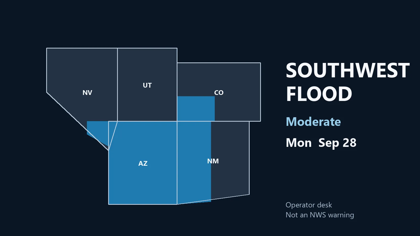
The SPC 1300 UTC Day 1 outlook has no severe thunderstorm areas and no convective watches are valid. The live organized desk is WPC Moderate excessive rainfall over portions of the Southwest and Four Corners as tropical moisture associated with Hurricane Polo and remnants of Odalys lifts north onto already wet ground. Overnight LSRs are isolated quarter hail in Cherry County, Nebraska and Willow Park, Parker County, Texas, plus isolated gusts in Sully County, South Dakota and Sutton County, Texas. Polo is a Baja and Sonora hurricane plus a U.S. moisture feed — not a CONUS landfall.
Owner / Principal
Hold a national CAT. The severe map is blank on purpose. Cash, overtime, and dumpsters belong on two desks only. First: water stage on Arizona, western and southwestern New Mexico, southwest Colorado, and southern Nevada ZIPs that sit under the WPC Moderate — pumps, extractors, sandbags, and extra dehumidifiers before afternoon cores, not after the first flash-flood warning. Second: daylight photo and estimate on last night’s Cherry County and Willow Park hail, plus the isolated 66 mph Sully County and 60 mph Sutton County gusts. Do not authorize overtime on quiet coasts or on the northern High Plains general-thunder corridor until a cell actually produces. Do not pull standing dry-in crews in the Northeast leftover zone to chase a Moderate flood polygon two time zones away. Polo does not get a California or Arizona landfall roster. Tuesday’s WPC language that keeps Moderate on parts of the Southwest, Rockies, and southern High Plains is tomorrow’s payroll, not today’s surge.
GM / Ops
Board three columns. Column A — live water: Flagstaff, Phoenix north and east slopes, Albuquerque west and south, Las Cruces, Lordsburg corridor, Durango/Farmington, and southern Nevada valley shops sit under Moderate rainfall language. On-call is extraction and traffic-safe access, not tree. Column B — just-hit: North Platte / Cherry County and Fort Worth / Parker County own yesterday’s quarter hail and limbs. Photograph in daylight. Column C — hold: Northeast coast leftover showers after the expired High Wind Warnings, and western Nebraska into the Dakotas general thunder this afternoon. Do not strip a standing commercial dry-out in New England or a mid-week rebuild in quiet states to staff a Four Corners fan that has not failed. Confirm the county product on weather.gov before a truck leaves a New Mexico burn-scar ZIP for a Nebraska hail ticket. High Plains isolated cells later today are a late check, not a branch shutdown.
Project Manager
Four Corners first four hours if a ticket verifies: exterior and approach photos while it is still safe, then extract before tarp unless the roof is open. Occupied homes get a category call, contents lift, and a moisture map before any wall comes down. Vacant commercial can take pumps and air movers once power and gas are confirmed. Burn-scar alluvial fans and slot-canyon drainages fail first — treat those addresses as sediment and Category 3 until proven otherwise. Photograph crawlspaces and finished basements on the first safe visit; the 24–48 hour mold clock starts when water is inside, not when the Moderate outline expires. Cherry County and Willow Park: daylight roof, vehicle, and soft-metal set first. Dual-peril houses that took wind-driven rain plus interior water log both perils on the same visit. Do not open walls until the PM signs the map.
Estimator
Three files, not one. Water: Moderate ERO on already wet soils is extraction, drying, and a mold-clock line even when the shingles look intact. Price standing water, saturated gypsum, and HVAC coil contamination from the meter map — not from a phone photo of a wet driveway. Hail: 1.00-inch reports south of Merriman and north of Whitman in Cherry County, and 2 miles north-northwest of Willow Park — density and fracture beat a dark evening shot. Wind: 66 mph at the Sully County mesonet and 60 mph west-southwest of Roosevelt, plus tree limbs on FM 730 near Willow Park — isolated gust, not a line. Do not price a full roof from last night’s photo. Do not fold Polo landfall language into a U.S. estimate. Do not fold expired Nebraska and Texas Severe Thunderstorm Warnings into a county-wide replacement. Price the address. Leave ALE for occupied residential after livability is known.
Technician
Meter and category before any wall opens. Overland flow on burn scars and rocky drainages is Category 3 until the source is proven clean. Wind-driven rain through a failed flashing is not automatically Category 1. PPE stays on for still-draining interiors. Outage blocks from last night’s isolated gusts: electrical safety first; generators stay outside and downwind; do not run air movers on an unverified panel. Hail jobs in Cherry County and Willow Park hide bruising in gutters and soft metal — photograph before discard. Do not start insulation removal until the PM signs the map. High Plains afternoon cells, if they fire, are isolated hail and outflow — same photo-before-demo rule. Northeast leftover coastal water is residual drying, not a new corridor.
Business Development
Call the people who already have water or already have hail, not the outlook. Commercial property managers on Mogollon Rim, Lordsburg, Sacramento Mountains, San Juan, and southern Nevada runoff ZIPs get a short local note — dock, elevator pit, after-hours access, pumps already staged. Residential adjusters on those same ZIPs get a moisture-map window, not a “we are in your neighborhood” blast. Cherry County and Parker County adjusters get a daylight photo offer on last night’s hail. Do not spray the entire Four Corners Moderate as a deploy. Do not pitch Polo as a U.S. hurricane landfall. Do not name clients. Confirm the county product before the note sounds like a watch is up. Northeast leftover accounts are standing drying jobs — check status, do not sell a new storm.
Commercial vs Residential
This event actually splits on water, not on wind. Four Corners commercial is warehouse roof ponding, dock wells, elevator pits, and after-hours access when training rain sits on already wet ground; residential in the same counties is finished basements, crawlspaces, contents, and ALE if the house is unlivable. Burn-scar fans hit both occupancy types with sediment — commercial loses yard and mechanical rooms first, residential loses living space. Cherry County and Willow Park hail is the opposite split: commercial is membrane, HVAC, and glass; residential is vehicles, soft metal, and living-space water only if the roof opened. Northeast leftover work is fading coastal debris and residual water, not a new commercial surge. High Plains this afternoon is thin on both occupancy types unless a cell verifies. Do not send one crew from a Lordsburg fan to a Cherry County roof without checking which county still has a product.
Close
Full weather pulse, pulse table, and official source list remain on the Tygart Media morning desk: Storm Updates: Southwest Flood Moderate, Quiet Severe Pulse — Monday, September 28, 2026 (Morning). For water protocol depth, see Storm Water Intrusion: Extraction, Drying, and Mitigation Protocol. For hail and isolated gust scope, see Wind and Hail Damage: Scope Development, Insurance Claims, and Repair Standards.
Informational operator brief only — not an official NWS warning. Verify every county and ZIP with weather.gov and local emergency management before rolling. Turn around, don’t drown.